Interactive World Map for Elementor – Mapper
299.880₫ Giá gốc là: 299.880₫.59.976₫Giá hiện tại là: 59.976₫.
The Mapper is a WordPress plugin for Elementor to add an informative colorful interactive map anywhere on your site page. Create unlimited maps for countries, continents or regions. Choose the map display mode that best suits your goals and wishes. With a minimum of effort and time, you can add the necessary data, configure tooltips to demonstrate the necessary information to your visitors in a creative and clear way.
This multi-purpose tool can be used to display various kinds of statistics, different regional information or show the placement of offices, companies, attractions, organizations, etc. The Mapper plugin is perfect for travel websites, personal travel blogs, chain stores, multinational companies, real estate, various infographics and so on.
Focus on different regions
You can display different types of maps:
- The whole world
- Specific continent(Africa, Europe, Americas, Asia, Oceania) or sub-continent(Northern Africa, Western Europe, Central Asia, etc).
- A specific country
- A certain country with its provinces/states(USA, Australia, Germany, Canada and many others)
- The United States is divided by metropolitan areas.
Map display modes
The Mapper offers different ways to highlight areas:
- Regions – applies selected color for a certain region such as a country, province or state
- Markers – adds a marker in the form of a point, icon or image for specified regions. The marker can be set in different colors and sizes.
- Text – adds text to point to a specific region.
Interactive feature
To make the map interactive and more informative, you can enable the display of tooltips with additional information. A trigger for the tooltip display can be a hover or a click on a specific region.
Color the regions depending on the values
The function is useful for displaying some kind of statistics, comparing different regions for certain values. You can select a color axis and the regions will be colored according to the specified values. Displaying the legend will help you better understand the data range being used.
Style customization
The styles of the near almost map element be customized according to your wishes and needs. You can configure the height and width of the map; the background color of the map, tooltips and other items; the color of Inactive regions or individual active regions, markers, fonts; the size and border configuration of different elements.
Five prepared templates included
We made sure that it was easy for you to get started with the Mapper plugin. With the plugin, you get 5 unique stylized and go-to-use templates. These are just some examples that can inspire you to create your style. It provides you a quick start in a few clicks.
Features of the Mapper plugin for Elementor
- Unlimited interactive maps on the page and site
- Supports different kinds of maps: continents, subcontinents, countries, states, regions
- Supports three display modes: regions, markers, text
- Two triggers of a tooltip: hover and action
- Includes the mode with a legend when region color depends on the value
- Overlay feature included
- Supports three marker types: default point, icon and image.
- Сolor management of active and inactive regions
- Supports different languages
- Icon management
- Flexible style settings
- Responsiveness settings
- Perfect for Elementor 2.5 and higher
- Works well with all WordPress themes built on Elementor
- Totally SEO Friendly
- Included pot file for quick translation on any language
- Perfect for RTL direction
- Fast and smooth installing
- Tested and compatible up to WordPress 5+
- Lightweight and Fast
- All major browsers supported Chrome, Firefox, Safari, Opera, and Edge
- Easy to use and customize with modern User Interface
- Installation Guide and detailed Users Manual
- Six months Included Support for CodeCanyon buyers
The plugin installation takes only a few seconds. Also, you do not need to make any additional settings. The plugin is ready to work immediately after installation – you only need to install and activate it in WordPress. Read more about capabilities and settings in the Online Documentation.
Changelog
1.0.4 – 8 December 2022
Added responsive controls for map width and height
Added percents for tooltip width and height controls
1.0.3 – 13 October 2022
Fixed script dependencies
Improved support for different php versions
1.0.2 – 23 July 2022
Fixed empty settings notices
1.0.1 – 16 June 2022
Added magnifying glass zoom factor setting
1.0.0 – 6 May 2022
Initial release
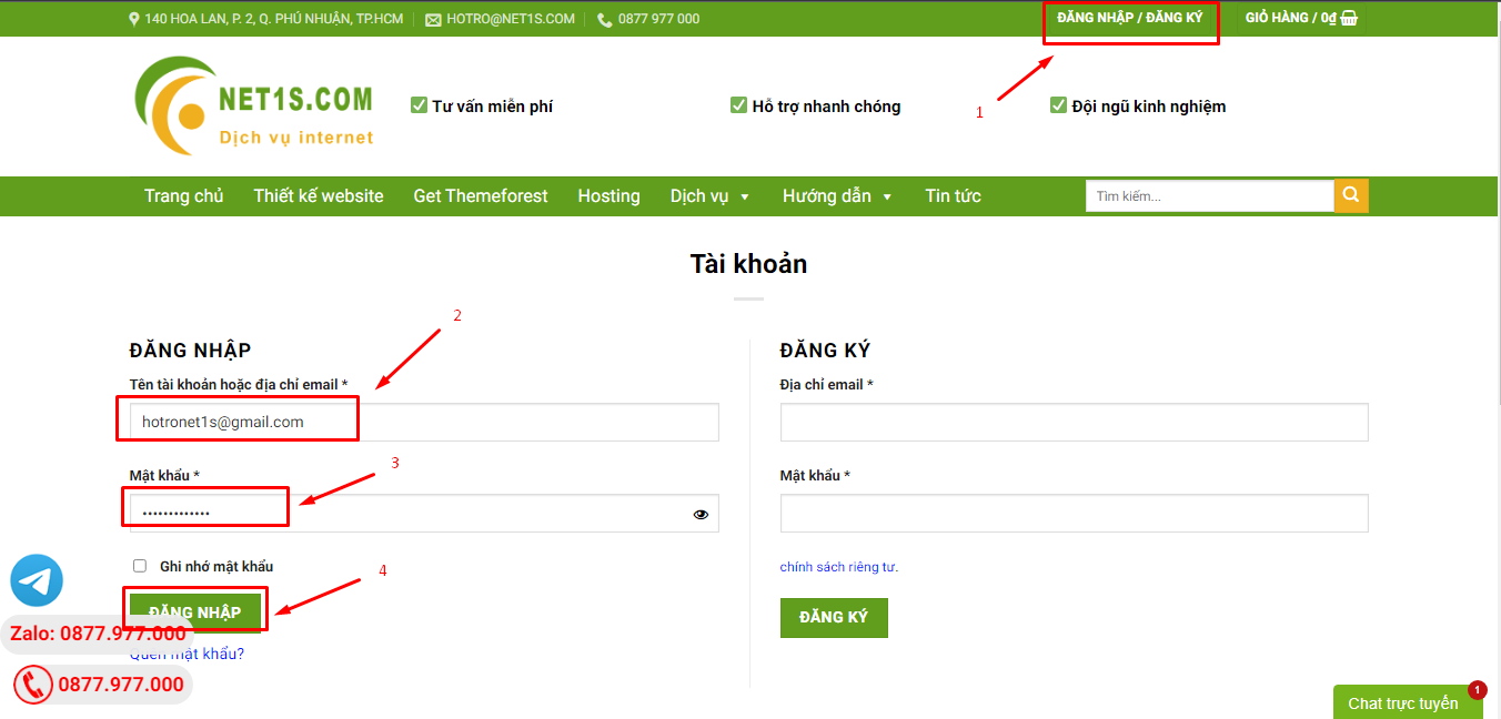
1. Bấm Đăng nhập/đăng ký.
2. Điền thông tin email, mật khẩu đã mua hàng -> bấm Đăng nhập.
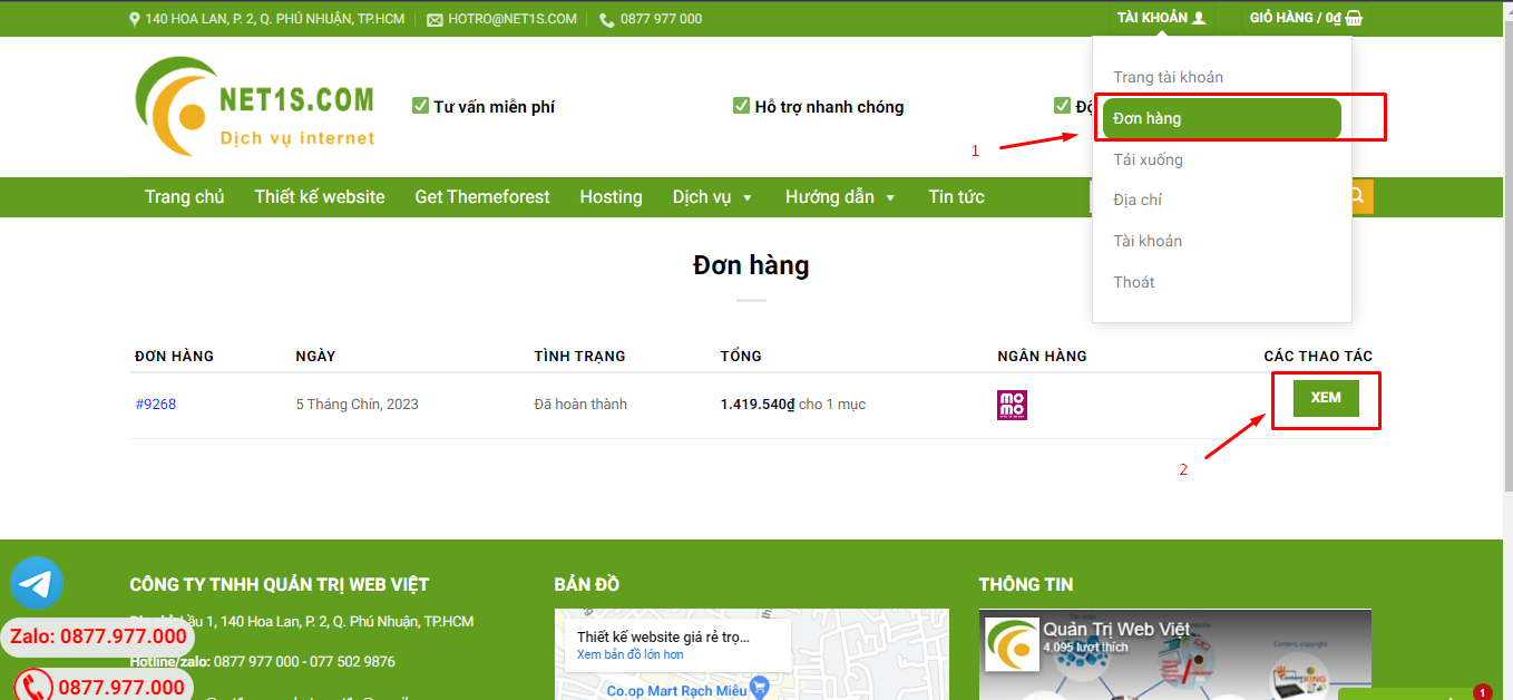
3. Di chuột đến mục Tài khoản -> Đơn hàng -> bấm vào Xem ở đơn hàng đã mua.
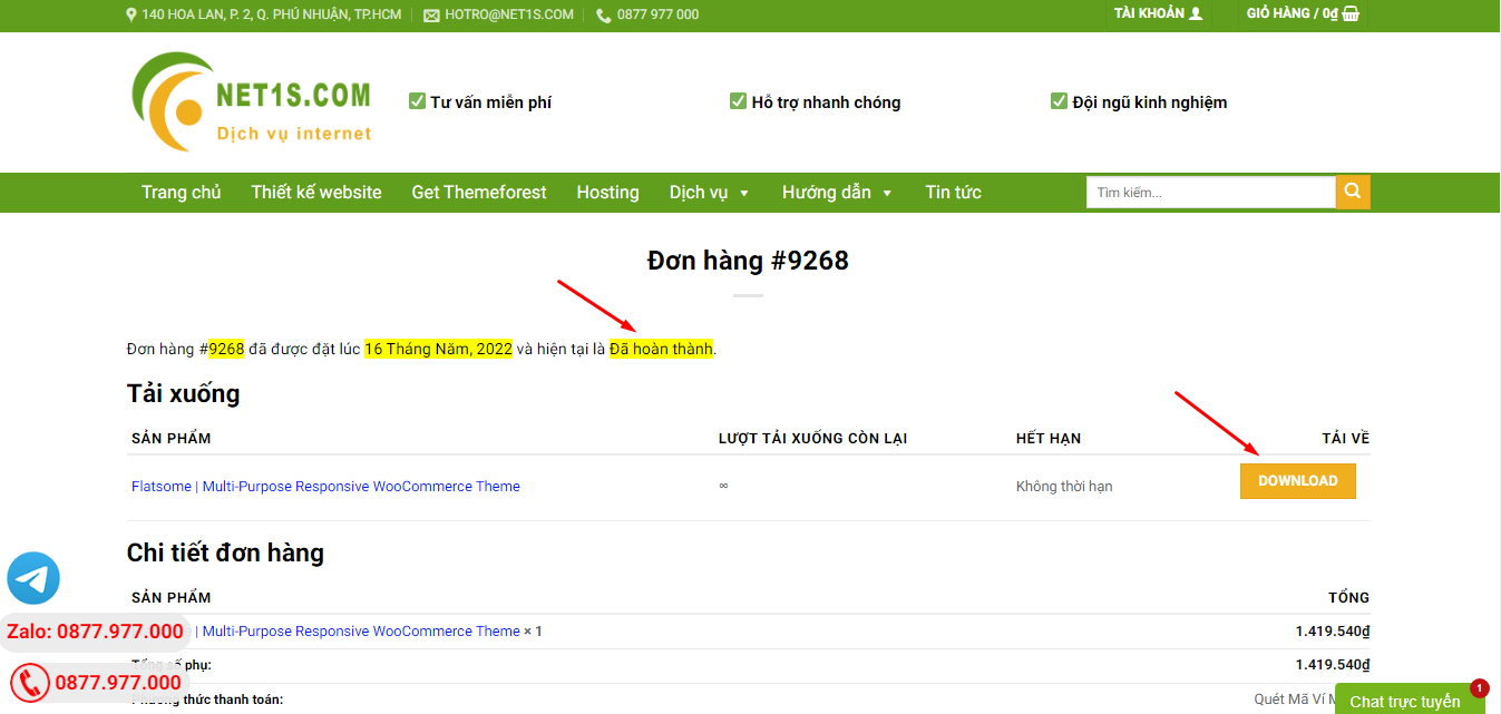
4. Đơn hàng hiển thị tình trạng Đã hoàn thành -> bấm vào Download để tải sản phẩm về.
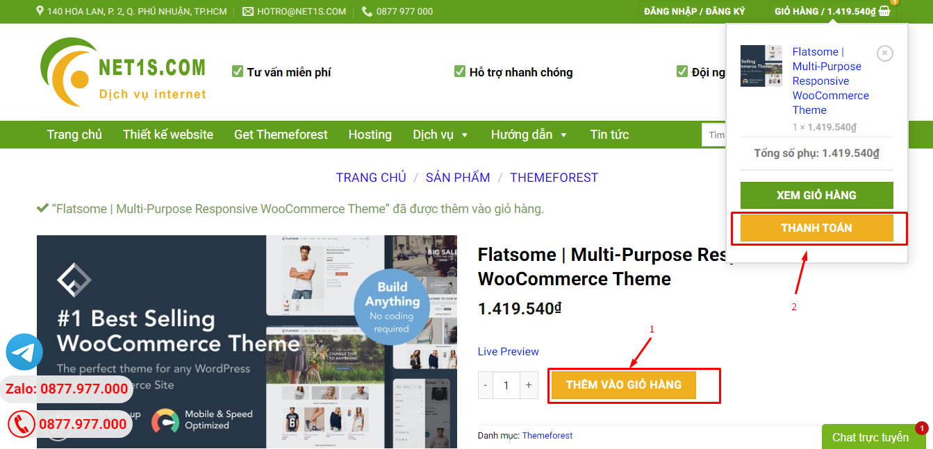
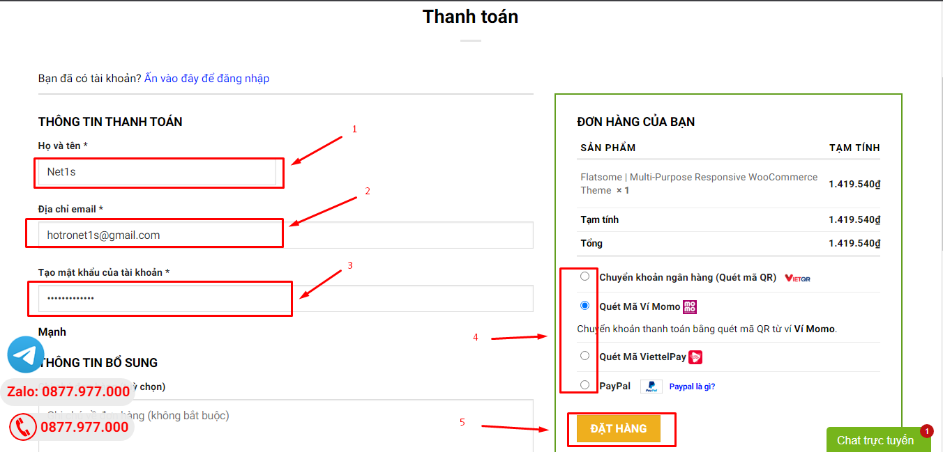
1. Bấm Thêm vào giỏ hàng -> bảng thông tin giỏ hàng sẽ hiển thị góc trên bên phải.
2. Bấm Thanh toán.
3. Điền thông tin thanh toán gồm: tên, email, mật khẩu.
4. Chọn phương thức thanh toán có hỗ trợ gồm: Chuyển khoản ngân hàng (quét mã QR), quét mã Momo, quét mã Viettelpay, Paypal.
5. Bấm Đặt hàng để tiếp tục.
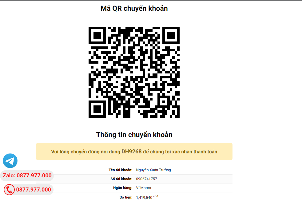
5. Thanh toán bằng cách quét mã QR (Nội dung chuyển khoản và số tiền sẽ tự động được tạo), hoặc chuyển khoản nhập số tiền và nội dung chuyển khoản như hướng dẫn.
6. Sau khi thanh toán xong đơn hàng sẽ được chúng tôi xác nhận đã hoàn thành và bạn có thể vào mục Đơn hàng để tải sản phẩm đã mua về.
Sản phẩm tương tự
Codecanyon
Codecanyon
Codecanyon
Codecanyon
Codecanyon


